

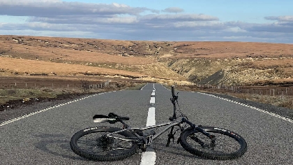
Snake Pass is one of Derbyshire’s most crucial yet notorious roads, crossing the Pennines and Peak District and connecting Manchester and Sheffield.
It is a route renowned for being host to expansive views across protected countryside as well as being a popular cycling hotspot, but it is also notorious for being periodically closed on a regular basis.
The 39-mile route between Manchester and Sheffield takes an hour and 30 minutes in favourable conditions.
When snow hits the Peak District it is Snake Pass which is often the first to close, due to its lofty and perilous position.
Bad weather in recent years has led to an increase in landslips and associated extensive road closures.
These have involved partial and entire closures of the route to all traffic – leading to protests by cyclists.
The most recent re-slipping of a landslip at the Gillott Hey section of the route will see roadworks in place until September 24.
Meanwhile, traffic lights remain in place slightly further west, at the Alport landslip, which could remain in place until the end of the year.
There have previously been talks of a radical new tunnel route under the Pennines to create more sustainable travel between two of England’s major cities, in a boost for businesses, commuters and travellers.
The Trans-Pennine Tunnel plan, first pitched in 2016, would be 25-miles long and cost up to £12 billion.
This would be wholly reliant on national funding, Derbyshire County Council says.
Council officials are mindful that increasing capacity on the route would be beneficial but suspect the planning barriers may prove prohibitive, along with public objections.
The council says it already only has resources for routine repairs and not enough for long-term works, and is in search of funding from Government or the new East Midlands Mayor.
Meanwhile, residents have often mooted that the route could go the way of the former road along Mam Tor, which slipped off the hillside and was too costly to repair and subsequently abandoned in 1977, leaving the well-known Winnats Pass as the only route through the surrounding hills.
The council “hopes” it can always keep the route open.
In light of these issues, the Local Democracy Reporting Service sent a list of questions to Derbyshire County Council, which is responsible for the route. Here are its responses.
QUESTION
How much money has the council had to spend on Snake Pass over the past three years?
ANSWER
We’ve spent around £26,000 on the routine maintenance of two landslip sites over the last three years, and approximately £100,000 on a ground investigation at the most recent failure at Alport following the winter storms in Feb 2022.
We’ve also carried out surface dressing over the last few years on the wider road, and we have the traffic lights and weight restriction signs in place because of the landslips and access.
QUESTION
Is it the road that requires the largest number of repairs?
ANSWER
It is the road with the largest number of landslips. What we are seeing are more landslips on the Snake Pass because the weather is getting wetter.
Since 2023 the county has experienced some of its highest rainfall on record, leading to more landslips and then a need for us to carry out repairs.
QUESTION
Is it the hardest road, logistically, to repair?
ANSWER
Because of the number of slips on this road, and movement of the surrounding land, as well as the base geology in this area, Snake Pass has seen the most combined landslips over recent years.
We are looking for funding to do more detailed ground investigation works to then inform longer lasting repairs of the slips on the road.
QUESTION
Is there a feasible long-term plan for how to prevent the road continuing to slip?
ANSWER
No, you can’t plan for a landslip. The only solution to try to prevent landslips would be to build a new road, which is not realistic.
QUESTION
Some residents suspect the road could go the way of the former Mam Tor Road and slip off the hillside, has the council accounted for this possibility? Is it realistic?
ANSWER
Our records go back over 90 years, and there have been slips since these began. A large portion of the A57 between Gillot Hey and Oyster Clough is built on landslip deposits.
It is realistic to say that movement will always occur at these sites and hopefully we will always be able to keep the road open.
QUESTION
Has the council considered creating some form of alternative route to Snake Pass?
ANSWER
No, the economic cost of this alone would be prohibitive unless national funding and support was made available to the Authority. The road also passes through the Peak District National Park, and any new road would be difficult to plan.
There are other routes between Sheffield, Manchester and Glossop, but all of these do usually take longer so we do appreciate both the local and regional strategic importance of the road, and this is why we have been highlighting both this and other major landslips in the county at a national level to make the case for additional funding for repairs and solutions.
QUESTION
Does it feel the route is a major burden to its resources?
ANSWER
At the moment we are able to meet the costs of the routine repairs we have been doing from our budgets.
We do not have the funds available to carry out any wider work, or put right the slip where we currently have traffic lights. This would take national funding, which is what we have been making the case for, both to the Department for Transport and the new regional Mayor.
 Hospice fumes at "scandalous" charity shop break in
 Egg-ceptional work! Ava-Grace's ambulance wins over NWAS
 Police Federation head dubious of PM's 'new bobbies' promise
 TransPennine Express steps in to keep passengers moving this Easter weekend